
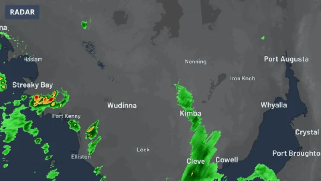
Two days of violent weather have swept across southern and eastern Australia. A storm on Thursday knocked down high-voltage towers and blacked out most of a South Australian peninsula, and on Friday severe thunderstorm warnings were active in Victoria, New South Wales and Queensland.
What Is Driving It
The cause is an upper-level trough, a pocket of cold, unstable air high in the atmosphere, which crossed southeastern Australia this week. It set off widespread rain and thunderstorms on both Thursday and Friday.
Friday’s storms were active over the inland from early in the day. They grew stronger and more widespread in the afternoon as the sun heated the ground.
Every state and territory had some chance of a thunderstorm on Friday, the Bureau of Meteorology said.
South Australia: Towers Down, Thousands in the Dark
The most serious damage came on Thursday afternoon on the Eyre Peninsula, where one intense storm cell hit the main power line serving the region.
- When: The towers came down at about 3 p.m. Thursday, and customers south and west of Whyalla lost supply, according to network operator ElectraNet.
- How many: SA Power Networks put the number of properties cut off at more than 24,000.
- The damage: Two towers fell and a third was damaged, on a line that had been upgraded only three years earlier.
- On farms: Farmers also lost crops and shed doors in what has been described as a “rare” supercell.
- Emergency powers: An electricity supply emergency is now in force, declared by Energy Minister Tom Koutsantonis on Thursday evening.
- Progress: The outage had shrunk to about 6,000 properties by 1:30 p.m. Friday.
Premier Peter Malinauskas has promised an independent examination of why the line failed.
New South Wales: A Soaking for the Outback
As the trough moved east, the storms followed it. Some parts of western New South Wales had their heaviest rain in about three years in the 24 hours to 9 a.m. Friday.
- Bourke: 70.6 mm (about 2.8 inches), the town’s wettest November day since 1984.
- Wanaaring: This far-west settlement took 60.2 mm (about 2.4 inches) in just two hours on Thursday afternoon.
The risk on Friday was highest in the far north of the state. Bureau forecasters flagged the country north of Cobar toward the Queensland border as the zone where destructive winds and giant hail were possible.
Victoria: Short, Intense Bursts
Victoria’s storms on Friday afternoon were brief but heavy:
- Dookie, near Shepparton: 16 mm (0.6 inches) in 30 minutes, shortly after 4 p.m.
- Addington: 28 mm (1.1 inches) in one hour.
The Bureau’s 6:29 p.m. warning covered parts of the Central, Mallee, South West, Northern Country, North Central and Wimmera districts, for heavy rain and damaging winds. The Bureau said flash flooding was possible.
Queensland: Warnings in the Far West
Severe storms were also under way in southwest Queensland. Quilpie, Windorah, Adavale and Eromanga were among the towns named in the midday warning for damaging winds and heavy rain.
Where Warnings Stood on Friday Evening
| State | Areas under warning | Main threats |
|---|---|---|
| Victoria | Central, western and northern districts | Heavy rain, damaging winds, flash flooding |
| New South Wales | Western districts | Heavy rain, damaging winds |
| Queensland | Western and southwestern districts | Damaging winds, heavy rain |
Forecasters expected the dangerous storms to continue into Friday evening.
What Comes Next
- This weekend: more showers and thunderstorms across eastern and southeastern Australia, but generally weaker and less widespread than on Thursday and Friday.
- Early next week: a second upper-level trough is expected to bring heavier rain and severe storms back to parts of Queensland and New South Wales.
People in affected areas should keep checking the latest Bureau of Meteorology warnings, since storm warnings are updated every few hours.

Walter M. Hartman is a writer at smhsbreeze.com, where he covers weather, school news, college news, and other stories. He focuses on clear, accurate, and timely reporting that keeps students, families, and readers informed about what matters in their community.